

Miscellaneous Ramblings
 03-03-2010, 02:41 PM
#11
Gets Weekends Off
Joined APC: Dec 2007
Position: EMB120 Left
Posts: 629
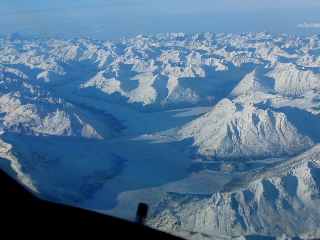

My picture is shot on the same lake, unfortunately I don't have a actual shot of the the ring. I can tell you that the ring is actually another lake inside of a lake, which is called Shamrock Lake. There's a proposal to build a hydro electric plant on the larger lake. Chakachamna Hydropower Licensing Web Site, TDX Power
 03-03-2010, 02:43 PM
#12
Airport Hobo
Joined APC: Apr 2007
Posts: 844
I guess pilots can't also be considered geologists. ")
Alluvial fan - Wikipedia, the free encyclopedia
Looks to me like an alluvial fan formed from glacier run-off then subjected to rain on top of it creating the depression and smaller lake on top of it.
Alluvial fan - Wikipedia, the free encyclopedia
Looks to me like an alluvial fan formed from glacier run-off then subjected to rain on top of it creating the depression and smaller lake on top of it.
03-03-2010, 02:57 PM
#13
With The Resistance
Thread Starter
Joined APC: Jan 2006
Position: Burning the Agitprop of the Apparat
Posts: 6,191
I guess pilots can't also be considered geologists.
Alluvial fan - Wikipedia, the free encyclopedia
Looks to me like an alluvial fan formed from glacier run-off then subjected to rain on top of it creating the depression and smaller lake on top of it.
Alluvial fan - Wikipedia, the free encyclopedia
Looks to me like an alluvial fan formed from glacier run-off then subjected to rain on top of it creating the depression and smaller lake on top of it.
 03-03-2010, 07:20 PM
#14
Gets Weekends Off
Joined APC: Nov 2008
Position: Livin' the dream
Posts: 626
Shamrock Glacier, Jungle, in the first picture referencing the ring? Alaskan Atlas and Gazeteer page 80, D2?
Thanks for the heads up lat/lon wise Jungle. Never been there. Beautiful pictures you and FlyorDie have taken of the area.
Thanks for the heads up lat/lon wise Jungle. Never been there. Beautiful pictures you and FlyorDie have taken of the area.
03-04-2010, 12:05 AM
#15
With The Resistance
Thread Starter
Joined APC: Jan 2006
Position: Burning the Agitprop of the Apparat
Posts: 6,191
It is fed/created by two glaciers that merge at this point.
Shamrock lake search brings up something on the Kenai, not this place, although FOD has the edge on local geography-it is not the geography of common usage, since there are no people nearby to utter such words.
Shamrock Lake it is: http://maps.google.com/maps?f=q&sour...86209&t=h&z=11
You may have to pan left to see it, N61225W152677 or thereabouts.
Last edited by jungle; 03-04-2010 at 01:45 AM.


