

Airspace Sectional Charts
 07-27-2022, 12:44 PM
#1
Line Holder
Thread Starter
Joined APC: Jul 2022
Posts: 28
Can anyone recommend a good source for learning and understanding these charts? Im going through ground school and I still cant seem to get it. Its really my only area of struggle. Im using Sporty's for ground school if that matters. I can identify each airspace based on the lines and colors, but if you give me an airport and ask me the floor and ceiling of it and its under more than 1 airspace I cant seem to understand how to figure it out. Every time I think Ive figured it out I get it wrong. Im going through the PHAK also, but I learn best by being shown and a book doesnt do a good job of that. Sooo frustrated today with this haha. Thanks for any tips or advice you can give.
 07-27-2022, 01:37 PM
#2
All is fine at .79
Joined APC: Sep 2016
Position: Paahlot
Posts: 4,216
Airspace:
A
B
C
D
E
G
From high to low altitude and also from high to low class of Airspace.
So you can have a Class D airport (partially) underneath a Class C but it won’t extend into it.
You can have a Class C airport (partially) underneath a Class B but it won’t extend into it.
So the higher Airspace overrules if you will.
Example is Tampa Class B
07-27-2022, 04:32 PM
#3
Line Holder
Thread Starter
Joined APC: Jul 2022
Posts: 28
Airspace:
A
B
C
D
E
G
From high to low altitude and also from high to low class of Airspace.
So you can have a Class D airport (partially) underneath a Class C but it won’t extend into it.
You can have a Class C airport (partially) underneath a Class B but it won’t extend into it.
So the higher Airspace overrules if you will.
Example is Tampa Class B
A
B
C
D
E
G
From high to low altitude and also from high to low class of Airspace.
So you can have a Class D airport (partially) underneath a Class C but it won’t extend into it.
You can have a Class C airport (partially) underneath a Class B but it won’t extend into it.
So the higher Airspace overrules if you will.
Example is Tampa Class B
07-27-2022, 05:31 PM
#4
Prime Minister/Moderator

Joined APC: Jan 2006
Position: Engines Turn Or People Swim
Posts: 40,173
IIRC the Cessna book I used years ago covered that well. I did self-study and don't recall having any issues.
First thing I'd do is understand each airspace type and what it's rules are. Understand that well. Only then look at the charts, they will make more sense if you thoroughly understand the airspace.
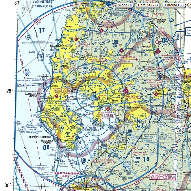
Plant city (PCM) is in the 100/30 boundary, so yes the B there is between 10K and 3000. Below 3K is under the B shelf, so some additional rules apply there as well. PCM is surrounded by a shaded magenta boundary, that's the class E down to 700 AGL (which is merged with the class E from other nearby small airports.
The boundary south of PCM is for a 100/60 shelf.
Lakeland is outside the B, but within the 30 mile mode C circle.
KSRQ to the south is outside the B because it's class C and has a circular carve-out from the B.
Don't confuse the light blue victor airways with darker blue B boundaries. Also the boundary colors aren't very consistent, you always have to look at the color AND the width and shading of boundary lines. There's a lot of magenta around SRQ...
Thick solid class C
Thin solid mode C veil
Thick shaded class E 700 AFL
Thin solid with dots ADIZ
Thin dashed isogonic line (mag variation, 5 degrees)
First thing I'd do is understand each airspace type and what it's rules are. Understand that well. Only then look at the charts, they will make more sense if you thoroughly understand the airspace.
Plant city (PCM) is in the 100/30 boundary, so yes the B there is between 10K and 3000. Below 3K is under the B shelf, so some additional rules apply there as well. PCM is surrounded by a shaded magenta boundary, that's the class E down to 700 AGL (which is merged with the class E from other nearby small airports.
The boundary south of PCM is for a 100/60 shelf.
Lakeland is outside the B, but within the 30 mile mode C circle.
KSRQ to the south is outside the B because it's class C and has a circular carve-out from the B.
Don't confuse the light blue victor airways with darker blue B boundaries. Also the boundary colors aren't very consistent, you always have to look at the color AND the width and shading of boundary lines. There's a lot of magenta around SRQ...
Thick solid class C
Thin solid mode C veil
Thick shaded class E 700 AFL
Thin solid with dots ADIZ
Thin dashed isogonic line (mag variation, 5 degrees)
07-27-2022, 10:38 PM
#5
Don't need that HUD!
Joined APC: Mar 2008
Position: B777/B787 - Flight Test
Posts: 318
Perhaps a study of the Aeronautical Chart Users' Guide - Visual Charting Products Only Edition from the FAA website would be helpful?
Page 55 provides a picture of a generalized airspace structure, while page 56 identifies specific items from the Detroit Sectional Chart in the Cleveland area.
With anything else on a sectional chart that you might have difficulty identifying, there should be an example and description of the item somewhere in the chapter about the Sectional Aeronautical Chart, pages 9 thru 39.
07-28-2022, 07:01 AM
#6
Line Holder
Thread Starter
Joined APC: Jul 2022
Posts: 28
Perhaps a study of the Aeronautical Chart Users' Guide - Visual Charting Products Only Edition from the FAA website would be helpful?
Page 55 provides a picture of a generalized airspace structure, while page 56 identifies specific items from the Detroit Sectional Chart in the Cleveland area.
With anything else on a sectional chart that you might have difficulty identifying, there should be an example and description of the item somewhere in the chapter about the Sectional Aeronautical Chart, pages 9 thru 39.
Page 55 provides a picture of a generalized airspace structure, while page 56 identifies specific items from the Detroit Sectional Chart in the Cleveland area.
With anything else on a sectional chart that you might have difficulty identifying, there should be an example and description of the item somewhere in the chapter about the Sectional Aeronautical Chart, pages 9 thru 39.
07-28-2022, 08:14 AM
#7
Gets Weekends Off
Joined APC: Feb 2019
Posts: 145
Airplane Flying Handbook and the Key that comes with the Sectional Chart should cover 99% of it. The depictions on the map describe things that only exist to aviators, so if you are struggling you may consider that your aviation base of knowledge is lacking. During training, I advise my students to read the Airplane Flying Handbook cover to cover several times. If you haven't done this in a while (or at all), do so now and see how that helps.
07-28-2022, 05:34 PM
#8
All is fine at .79
Joined APC: Sep 2016
Position: Paahlot
Posts: 4,216
Here’s another trick that may (or may not) help, go from high to low.
So for instance your example Plant City.
Airspace above down to the surface:
Class A down to 18,000’
Class E down to 10,000’
Class B down to 3,000’ (it’s underneath that segment)
Class E down to 700’
Class G down to the surface.
Lakeland next to it from high to low:
A,E,D to the surface within 30NM veil.

Thread
Thread Starter
Forum
Replies
Last Post


